ChinaKnowledge.de -
An Encyclopaedia on Chinese History and Literature
Zhihe tulüe 治河圖略 "Concise maps of controlling the Yellow River" is a book on water conservancy written by the Yuan-period 元 (1279-1368) scholar Wang Xi 王喜. The original book was lost at an early date.
It is a description of the measures taken after the heavy inundation of 1344 and describes the activities of water conservancy through the ages and especially points out errors and shortcomings in the past, in order to provide a reliable sketch for hydraulic works in the present. The book begins with 6 maps showing the geography of the Yellow River during antiquity (Yu hetu 禹河圖, showing the putative taming by Yu the Great 大禹 of the floods of the Yellow River), the Han 漢 (206 BCE-220 CE) and Song 宋 (960-1279) periods and the then-present age. Further maps give insight into hydraulic works, and one shows the source of the Yellow River. Each map is explained in a detailed account.
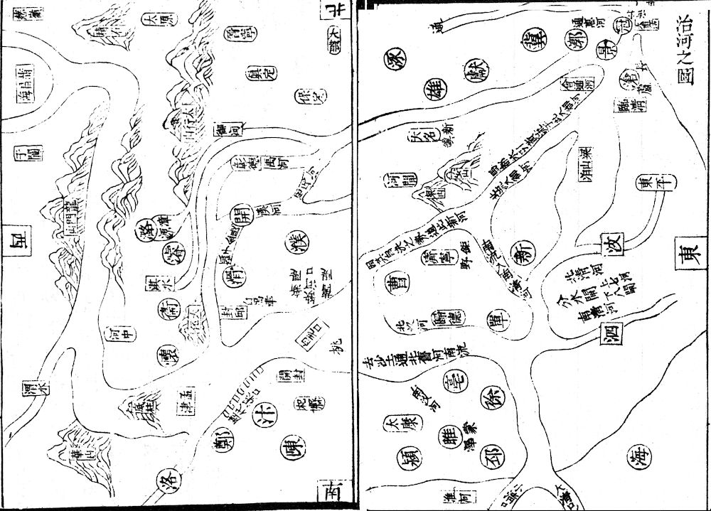 |
Illustration from the Zhihe tulüe (click to enlarge; opens in new tablet), showing very crudely the course of the Yellow River from the northern part of the Yellow River Bend to the estuary. The map is arranged like modern maps, with the north to the top. The rivers Wei 渭水 and Luo 洛水 shed their waters from the southwest, and a branch of the Yellow River goes to the southeast, to the sea (Xiao Qingkou 小清口 and Da Qingkou 大清口). The mouth of the Yellow River is to be found in the northeast, in Dazhigu 大直沽. The map has no unified scale, and the various branches of the Yellow River therefore look as they were crossing the province of Shanxi. |
Two chapters explain general strategies (Zhihe fanglüe 治河方略) and a history of water conservancy (Lidai juehe zonglun 歷代決河縂論). Wang Xi clearly saw that it was important to impede too much silt draining into the waters of the Yellow River. It was therefore of greatest interest also to take care for the stretches of the Yellow River in the upper course. While the old bed had to be preserved, a new bed would be created, so that the Yellow River was flowing in two beds, the one entering the Yellow Sea through the Liangshan Swamp 梁山泊, and the other flowing south of the Shandong peninsula into the River Huai 淮水. It was also important, he argued, that the official government entrusted a competent high official with the supervision of these works. Workers, he said, were to be recruited among the strongest men, and to be paid decently.
The Zhihe tulüe is included in the series Siku quanshu 四庫全書, Mohai jinhu 墨海金壺 and Congshu jicheng 叢書集成.